There are no products in your basket.
Deep archaeology and ‘biodegradable ROVs’
We had done it! As I watched my computer count down the last few seconds of deco I took stock of what we had achieved over the last couple of days: film for the internationally acclaimed TV show Coast Australia (check), carry an Explorers Club Expedition Flag (check), undertake the deepest maritime archaeological survey by technical divers in Australasian history (checkmate)! As I climbed back onto the boat, I thought of the hundreds of hours that had gone into researching and preparing for this project and how if it wasn’t for a daring but ultimately unsuccessful attack I wouldn’t have been there at all.
On the 31st of May 1942, a Japanese Naval strike force attacked Sydney Harbour with a fleet of top-secret Type A Ko-hyoteki Japanese midget submarines. Of the three subs, two were sunk with only one; the M-24 managing to fire its torpedoes and escape the harbour, but in doing so disappeared from history for 64 years until it was found in 56 metres of water in 2006. The discovery of the sub raised numerous questions. Fast forward to 2017: due to its depth, and status as a war grave protected by a potential fine of 1.2 million dollars, many of these questions remained unanswered.
To a maritime archaeologist and technical diver, the M-24 presented an exciting challenge; firstly, could I get access to the restricted site, and if access was granted, how could we survey this deep, internationally significant wreck site to archaeological standards? I began by writing an archaeological research proposal to the managers of the site, the Heritage Division of the New South Wales Office of Environment and Heritage, who thankfully supported the project and provided me with the necessary access paperwork.
With permit in hand, I assembled a highly skilled team of fellow rebreather divers who not only had the required skills but also the level of respect required for such a project. With this experienced team, we would record the wreck with HD video and photographs as well as map the site using photogrammetry, a technique that would allow us to create a 3D model of the M-24 wreck site.

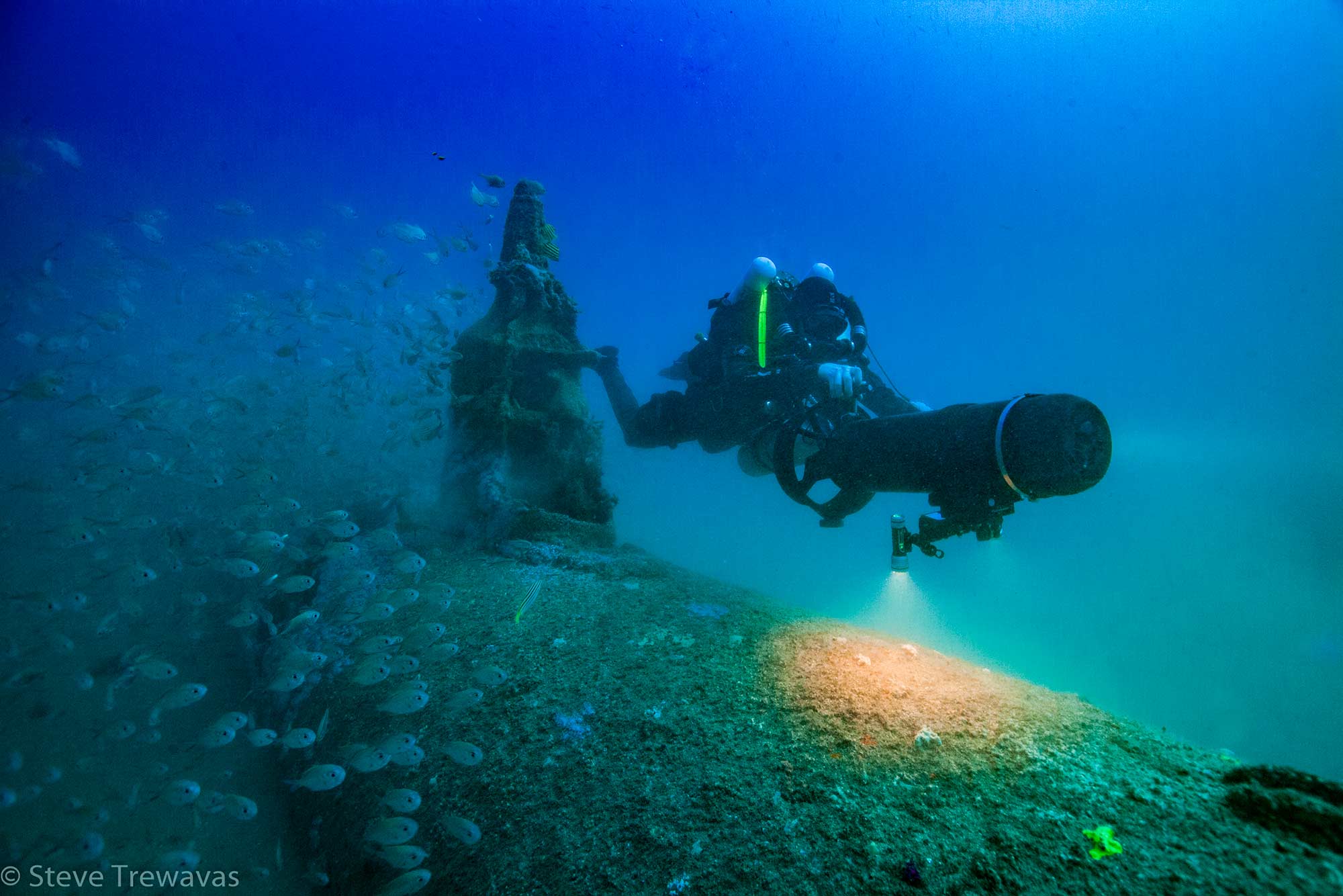
Image Credit: Steve Trewavas
A Happy Complication
With the team selected and the expedition date looming closer, I received an email that although welcome, would significantly increase the logistics of the project. For the last three years I have had the incredible experience of working as a specialist presenter on the television series ‘Coast: New Zealand’, a spin-off from the BBC-produced UK series ‘Coast’. The email I received that day was from the producers of ‘Coast: Australia’ the sister production of ‘Coast: New Zealand’. They had heard about our project to record the M-24 and wanted to film it for an episode in their forthcoming season to be aired on Foxtel’s History Channel. After discussions, it was agreed that we would complete our survey as planned and that we would be filmed above water by the Coast Australia crew, and below by a specially contracted Remotely Operated Vehicle (ROV). As you can imagine, surveying the site at this depth and filming the process with the ROV would require a great deal of coordination. Before the dive, we discussed with the ROV pilot how this could be achieved, and it was then to our astonishment that he jokingly referred to the dive team as “the biodegradable ROVs”. We took this banter of us being inferior to the little box with blinking lights in good spirits but knew that there were high expectations for us to record the site and get the results we needed as safely and efficiently as possible.
The Survey
As we descended down the shot line we could hear the whir of the propellers from the ROV as it followed us down towards the wreck site. As we got closer and our torches lit up the schools of fish blanketing the site, we could see the submarine slowly take shape out of the darkness. On the bottom, we quickly got to work filming and taking photos of the various features of the wreck site while the ROV followed us, recording the action. Using a SUEX scooter with attached camera system I crisscrossed the wreck, scanning it to gather the data for the 3D model. As planned, after 40 minutes of recording we began our slow ascent to the surface and over the next 80 minutes of deco my mind raced over what we had recorded, hoping it would be enough.
After a couple of topside interviews with the Coast film crew, we could finally download the footage from the dive and begin to process the 3D model. Growing increasingly impatient, I had to wait another few days for the model to finally be revealed. We had prevailed. In front of me was the M-24 exactly as it appeared on the bottom, providing a perspective of the sub not seen since it was launched on that fateful night in 1942. My project to archaeologically record the M-24 had been a complete success; not only had we recorded the wreck site in unprecedented detail but we had also shown that wrecks within the technical depth range can be recorded safely and effectively to archaeological standards – not bad for a bunch of biodegradable ROVs!
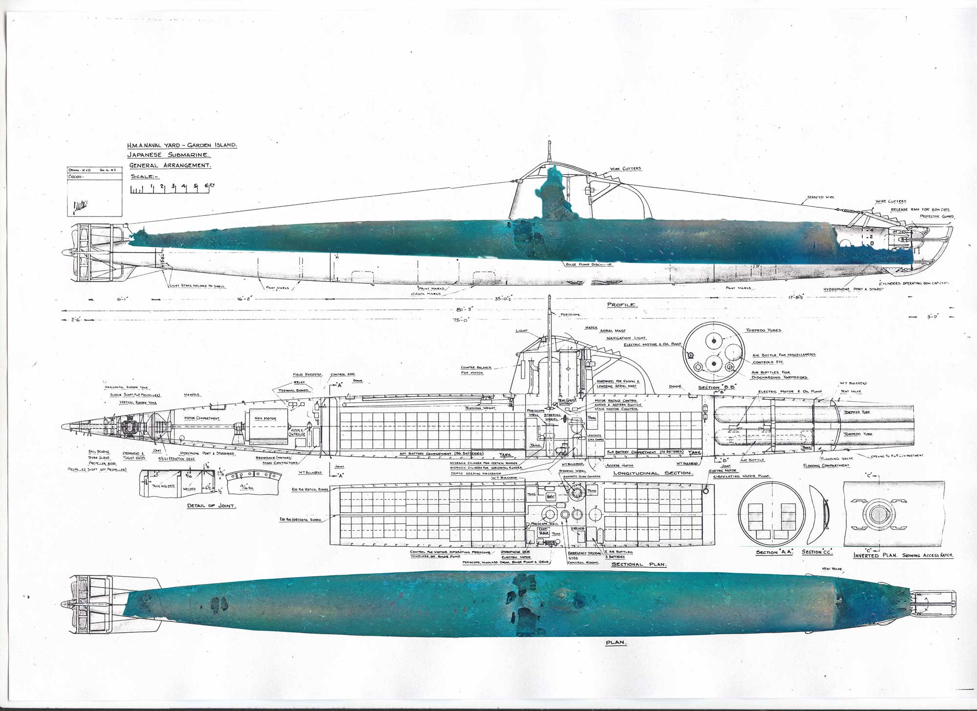
3D model overlaid on midget submarine plans
Image Credit: ARCHAEOTechnic